 |
|
Ski
Resorts Snowshoeing Soccer Swimming Tennis
Clubs Theaters Theaters Train
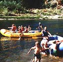
Rides Whitewater Rafting down a
river can be an exhilarating adventure. Whitewater
rafting can also be very challenging. Please
contact a professional rafting company before
setting out on any river without a
guide. Canyon Raft Rentals Tributary
Whitewater
Tours Recreational Areas and Information PLEASE HELP PRESERVE NEVADA
COUNTY'S RECREATIONAL ENVIRONMENT BY RESPECTING MOTHER
NATURE. DON'T LITTER, PLEASE DON'T TRESPASS ON PRIVATE
PROPERTY, CARRY NECESSARY PERMITS AND HAVE FUN! Natural Recreation Areas Biking • Round Mountain Trails: Hwy. 49 out of N. C. to
North Bloomfield Rd. to Rock Creek
Rd. Series of trails, including Round
Mountain. Some level to steep,
intermediate
to advanced. • Pioneer Trail: Essentially follows scenic Hwy.
20 out of N.C. Start in town taking
Willow Valley Rd. to Hwy. 20 and Harmony
Ridge Market where trail begins. Can
also start from Omega Rest Stop 18 miles up
Hwy. 20 Rolling, beginner to advanced. • Washington Roads: Omega Loop from Omega Rest
Stop on Hwy. 20. Rolling uphill,
intermediate. Nearby Alpha Road left on
Omega Rd. off Hwy. 20 Steep, advanced.
Maybert Rd. after crossing Yuba River in
town of Washington. Level, beginner to
intermediate. Artic Mine Road reached from
Maybert Rd. Level, strong beginner to
intermediate. • Bullards Bar Reservoir: Hwy. 49 out of N.C. on
way to Downieville, turn left before
Camptonville at Marysville Road. Park at Doc
Willy's head up Old Camptonville
Road. Level, intermediate through
advanced. • North Yuba Trail: Hwy.49 out of N.C. toward
Downieville. After crossing North Fork
of Yuba River, park at Rocky Rest
Campground. Cross river on foot bridge.
Level,
intermediate to advanced, 15 miles out and
back. • Empire Mine State Historic Park: Part of Park's
trail system on both sides of Hwy. 174.
Level, beginner to intermediate. Maps at
park Visitor's Center, 10791 E. Empire
St. Grass
Valley. Boating • Rollins Lake: Accessible from
Hwy. 174, 530-346-6166 • Scott's Flat Lake: Off Hwy.
20, 530-265-5302 • Englebright Lake: Off Hwy. 20
past Penn Valley, 530-639-2342 • Bullard's Bar Reservoir: Yuba
County off Hwy. 49, 530-692-3200 • Collins Lake: Marysville Rd.
off Hwy 20 toward Marysville,
800-286-0576 • Donner Lake-West End: Off
I-80, 530-582-7720 • Stampede/Boca Reservoir
Areas: Off I-80 seven miles east of Truckee, Tahoe
National Forest • Prosser Reservoir: Off Hwy.
89 exit of I-80, Tahoe National Forest Campgrounds State Campgrounds 111• Malakoff Diggins Campground 111•
Eagle Mountain Resort 111•
Big Bend Campground 111•
Boca Campground • Rollins Lake: Accessible from
Hwy. 174, 530-346-6166 • Scott's Flat Lake: Off Hwy.
20, 530-265-5302 • Englebright Lake: Off Hwy. 20
past Penn Valley, 530-639-2342 • Collins Lake: Marysville Rd.
off Hwy 20 toward Marysville,
530-692-1600 Tahoe National Forest - Truckee District, 530-587-3558 • Stampede/Boca Reservoir
Areas: Off I-80 seven miles east of Truckee,
Tahoe
National Forest. Rainbow
trout planted yearly. Also brown trout, Kokanee
salmon.
Lake trout. • Truckee River: From Truckee
to Grey Creek, accessed from I-80. Large brown
trout,
small population of
rainbow trout. Some restrictions apply. • Little Truckee River: Section
between Stampede and Boca Reservoirs.
Brown
trout reproducing
naturally, also rainbow trout. • Prosser Reservoir: Off Hwy.
89 north of I-80 from Truckee. Fingerling
and
catchable rainbow trout
planted yearly. Brown trout reproducing
naturally. • Alder Creek/Prosser Creek:
Off Hwy. 89 north of I-80. Best in spring,
small
numbers of native brook
and rainbow trout. • Sagehen Creek: Off Hwy 89
north of I-80. Small, wild rainbow, brook and
brown
trout in reaches of
creek. Above Hwy. 89 bridge, some
restrictions. • Martis Reservoir: State Hwy.
267 south of Truckee. Catch and release,
only
artificial lures with
single barbless hooks. • Donner Lake: I-80, two miles
west of Truckee. Catchable rainbow trout planted
yearly. 111111•
Some Mackinaw (lake
trout), Kokanee, popular with anglers, several
piers, boat launching. • Soda Springs/Norden Area:
Accessed north of I-80. Warren Lake, Lahontan
cutthroat
trout planted yearly,
accessible by hiking trail only. Summit Lake,
fingerling brook
trout planted yearly,
accessible by hiking trail or very rough 4-WD road.
Negro
Canyon Creek, small
population of brook trout. Tahoe National Forest - Nevada City District, 530-265-4531 • Cisco Grove Area: Off I-80 to
north. Several lakes and pond, trout, some planted
yearly. • Grouse Lakes Area: Hwy. 20
from either I-80 or Nevada City, turn at Bowman
Road.
Series of lakes, area
closed to motor vehicles, trout, some
planted. • Bowman Lake: Bowman Road, 16
miles north of Hwy. 20. Fingerling rainbow
and
brown trout planted
yearly, larger browns found, boat angling better,
4-WD not necessary. • Fuller Lake: Off Bowman Road.
Catchable rainbow trout planted yearly, some
brown
trout, good access for
bank fishing, popular. • Rucker Lake: Off Bowman Road.
Contains special strain of rainbow called
redband
trout, popular. Nearby,
Blue Lake, fingerling rainbows planted
yearly. • Off Bowman Road: Before
reaching Bowman Lake and near Lake. Group of
lakes,
trout, some
planted. • Lake Spaulding: Off Hwy. 20
near I-80 at Spaulding Road. Fingerling rainbow
and
brown trout planted.
Native rainbows, browns and brook trout, carp and
pond
smelt. Boat
ramp. • Bear River: Hwy. 20 near
Bowman Road. A few catchable rainbow trout
planted
yearly, some native brown
and rainbow trout. • South Fork Yuba River: Hwy.
20 to Washington Road. Catchable rainbow
trout
planted yearly, easily
accessed near town of Washington. Gold
Panning • South Yuba River State Park
at Bridgeport: Old Hwy. 20 out of Grass Valley
to
picturesque Bitney
Springs Road, right on Pleasant Valley Road, park.
Gold Panning
tours available June
through September, Saturday and Sunday, call for
times. • Hands and pans only.
530-432-2546 • Town of Washington: East of
N.C. off Hwy. 20 Pan at Tahoe N
sheet at TNF, 631 Coyote
St. Nevada City 530-265-4531
Hiking • Independence Trail: Two 2.5
mile sections and 4.3 mile loop, wheelchair
accessible,
flat, historic. North of
Nevada City off Hwy. 49. • Steephollow: Wheelchair
accessible, located at Rest Area on Hwy. 20 east of
N. C.,
steephollow ponderosa and
sugar pine plantations, interpretive, includes
hydraulic
mining history. Tahoe
National Forest trail. Malakoff Diggins State Historic Park, 530-265-2740 • Rim Trail: Moderate, views of
hydraulic diggins, trailhead at North Bloomfield
Rd.
or Malakoff
Campground. • Diggins Loop: 3 mile loop
through hydraulic mining operation, easy, trailhead
at
Diggins Overlook, North
Bloomfield Rd. • Blair Trail: 1/2 mile loop,
easy, trailhead at North Bloomfield Rd. near
North
Bloomfield. • North Bloomfield Trail: 3/4
of a mile, easy, trailhead at North Bloomfield Rd.
in
town of North
Bloomfield. • Humbug Creek Trail: 3 miles
each way, moderately difficult, connects with
South
Yuba at river, 1,000 ft.
return climb out of canyon, trailhead at North
Bloomfield Rd.
in park. Empire Mine State Historic Park, 530-273-8522 • Union Hill Trails: 1 mile to
3 miles, easy trailhead at Hwy.174 near Empire
St. • Hardrock Trail: 2 miles,
easy, circles much of Empire Mine "out back,"
trailhead at Park Visitors Center. • Osborn Hill: 1 mile loop, off
shoot of the Hardrock, more demanding,
overview
of Sacramento
Valley. South Yuba River State Historic Park, 530-432-2546 • Bridgeport Trails: Virginia
Turnpike Loop, .63 miles, easy; Point Defiance
Trail,
2.8 miles, easy to
moderate; Buttermilk Bend Trail, 1.4 miles, mostly
easy; Kneebone
Trail, 133 miles,
easy. • Hwy.49 Crossing Area: Jones
Bar Trail, .5 miles, easy to moderate; Hoyt Trail,
.9
miles,
moderate. • Blair Trail: 1/2 mile loop,
easy, trailhead at North Bloomfield Rd. near
North
Bloomfield. • Purdon Crossing Area: South
Yuba Trail, 4.5 miles, easy; Round Mountain
Trail,
1 mile, moderate; Old
Flume Trail, 17 miles, easy. • Edwards Crossing/North
Bloomfield Area: Spring Creek Trail, 14
miles,
moderate; Missouri Bar
Trail, 1.7 miles, easy. Tahoe National Forest - Nevada City Ranger District, 530-265-4531 • Pioneer Trail: 12 miles one
way, parallels scenic Hwy. 20, easy, trailhead 7
miles from
N.C. across from Lone
Grave. • Missouri Bar Trail: 1.7
miles, 1,200 foot descent to South Yuba River,
moderately
difficult, adjacent to
Malakoff State Park, trailhead at Relief Hill
Rd. • Scenic Grouse Lakes Area: 6
trails (Round Lake, Lindsey Lakes, Crooked
Lakes,
Beyers Lakes, Grouse
Ridge, Glacier Lake), from 2 1/4 one way to 8 1/8
miles one
way, moderately difficult
to difficult, access from Bowman Rd. off Hwy. 20
near I-80
and Eagle Lakes exit off
I-80. Tahoe National Forest - Truckee Ranger District, 530-587-3558 • Commemorative Overland
Emigrant Trail: 15 miles, trailheads at Alder Creek
Road
Donner Picnic Ground and
Stampede Reservoir. Parallels actual Overland
Emigrant
Trail, good in spring and
fall. Also used for mountain biking. • Glacier Meadow Loop Trail: .5
mile loop, very easy, self guided nature trail,
trailhead
at eastbound I-80 rest
stop at Donner Summit. • Lower Lola Montez Lake Trail:
3 miles one way, easy, take Soda Springs exit off
I-80,
on north side of freeway
follow paved road east to parking area. Also used
for
mountain
biking. • Pacific Crest Trail: Extends
from Canada to Mexico, Use Castle Peak -Boreal
Ridge
exit from I-80, turn
right and take a quick left to parking and
trailhead. To north,
through culvert, can
access Sand Ridge Lake Trail 4 miles in, 1.5 miles
one way,
moderate; Summit Lake
Trail 2 miles in,, 2 miles one way, easy; Warren
Lake Trail
3 miles in, 7 miles one
way, very difficult. Tahoe National Forest • Town of Boca Site: Historic,
new interpretive trail, photos, wheelchair
accessible.
I-80 east of Truckee to
Hirschdale, north under freeway. • Donner Camp Historic Site and
Picnic Area: Includes interpretive trail, easy.
Tells
story of members of
Donner Party that camped at site. I-80 to Hwy. 89
North exit,
two miles from
I-80. • Overland Emigrant Trail:
Glimpse life of pioneers who emigrated to
California more
than 130 years ago. Paved
and dirt roads, one hiking segment (see above).
Detailed
brochure and map at TNF
offices. • Big Bend Visitor Center:
Displays on local Native Americans, Emigrant Trail,
logging.
Off I-80, Big Bend turn
off, left on Rainbow Rd. (Hwy. 40), campground
nearby. Parks and Public Lands • Tahoe National Forest:
530-256-4531 • Foresthill: Placer County
Big Trees Grove, 530-256-4531 • South Yuba River State
Park, 530-432-2546 or 530-273-3884 Neighborhood: Picnicking, Playgrounds, multi-use fields, swimming pools • Dow Alexander - Bennett and
Bank Streets • Condon Park-Minnie Street off
Butler Street , 530-274-4390 • Minnie - Minnie and Brighton
Streets (entrance to Condon Park) • P.L.A.Y. - 225 S. Auburn
(behind Hennessey School) Designed by children,
14,000 sq. ft. park structure. • Memorial Park - Colfax
Highway, 530-274-4390 • Western Gateway Park - Penn
Valley Highway, Penn Valley,
530-432-1990 Snowmobiling • China Wall Snowmobile
Trailhead • North Tahoe Regional Park
Snowmobile Trailhead Sno-Parks Cleared parking areas near sites for cross country skiing, sledding, snowshoeing and snowmobiling. Permits are required. In Nevada County you can purchase permits at Donner Memorial Park (I-80) and Truckee, Nevada City and Grass Valley sporting goods and ski shops. Info: 916-324-1222 • China Wall: a no cost
sno-park operated by the U.S. Forest Service
featuring
cross-country skiing,
snowmobiling and family snow play. Just 14 miles
east of Foresthill. • Donner Summit at the Castle
Peak Exit off I-80 • The Yuba Gap Exit off
I-80. • The Cisco Grove Exit off
I-80 • Donner Lake off
I-80 |

Interested in a linked listing,
mini-web page, coupon or
sponsoring a category or page email
us for information
and rates.
Home | Hwy 49 Map | Cities Directory | Business Directory | Bed & Breakfast | Golf Courses | Wineries | Historic Churches
Gold Rush History | Historic Photo Gallery | Gold Facts | We The People | Ghosts | General Store | Old Sac | Tahoe | Yosemite
historichwy49.com
Since 1999
© 2000,
2001, 2002, 2003, & 2004 historichwy49.com
e-mail: info@historichwy49.com