 |
||
|
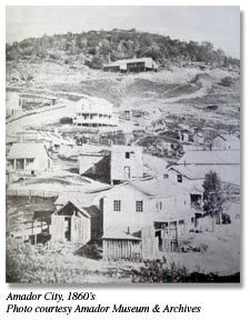
Early view, while not the
earliest photo of Amador City known, it certainly
is the most detailed. Recognizable are, foreground,
the Amador Hotel and Fleehart Building up the
street. Near the top of the hill is the Keystone
Mine. Just beneath the new-looking two-story at
left center is the Eclipse Mine with a hand-cranked
windlass. The Photo is believed to from the late
1860's. Jose
Maria Amador, a wealthy California rancher mined
along a nameless creek in 1848 and 1849. His
presence gave his surname to the creek, two
villages on its banks, and, in 1854, a new
county. There was no settlement where
Amador City is now until the summer of 1851, after
gold outcroppings had been prospected on both sides
of "Amadore's Creek", upstream several hundred
yards from downtown. The "Original" or "Little"
Amador mine and the Spring Hill were probably
Amador County's first gold mines. With the discovery of such
quartz gold, the settlement that was upstream where
the stage road crossed "Amadore's creek" or Amador
Crossing, gradually moved to ": South Amadore" or
Amador City where French Gulch drains into the
creek. The city's most famous and
productive mine, the Keystone was organized in 1853
out of two or more claims and before it closed for
good in 1942 it produced in intermittent operation
about $24 million in gold at much lower gold
prices! Amador City was incorporated
in 1915 and was the state's smallest such
municipality until recent years. Amador City's oldest building
is the main lobby portion of the Amador Hotel,
probably built in 1855. The Fleehart or Wells
Fargo building is the oldest store in town, dating
from the 1860's or earlier. The telephone came to town in
1878, electricity in the mid 1890's and the auto
just after the turn of the century.
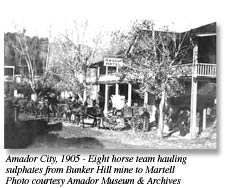
When the Keystone, original
Amador and Bunker Hill gold mines were all
operating, Amador City was a bustling community,
rivaling Sutter Creek and Jackson. The photo to the
right shows the an eight horse team standing ready
in front of the Amador Hotel, with the Imperial
Hotel to the left. The railroad arrived at Martell
in the early 1900s, and freight could be shipped
below from Martell. Like most of the towns in
gold country, the big fire of 1878 destroyed almost
every wood frame business building on main street
except for the Fleehart building and the front part
of the Amador Hotel. As the owners rebuilt in 1878,
they used stone or brick. Each building has the
original iron shutters on the front doors and
windows which were added protection from a fire
that could sweep through town. Tin roofs were also
a fire preventative measure, and in the attics they
placed sand and bricks which helped prevent sparks
from dropping down. Because of these measures, all
the existing buildings survived and are all in
their original state, over 120 years
later
Before statehood, what is now
Amador was part of the San Joaquin District and in
the 1849 statewide elections, had at least three
precincts - Drytown, Volcano, and Buena Vista
Ranch. When California became a state in 1850, this
area became part of Calaveras County - one of the
original twenty-seven counties organized. But
citizens north of the Mokelumne River quickly
became dissatisfied with being a stepchild
province. After several years agitation, the county
was divided in 1854 and on that June 14 Amador was
born. In later years it acquired
land north of Dry Creek from El Dorado County and
gave up easterly Sierra territory when Alpine
County was formed in 1864. Jackson, which had been
the county seat of Calaveras for a time in
1851-1852, edged out Volcano to become county seat
of the new county. Volcano threatened to wrest the
honor away in 1857, but the effort was stymied in
the Legislature at the eleventh hour. Amador County is the only
county in the state named after a non-Indian native
Californian, Jose Maria Amador, a wealthy ranchero
before the gold rush, whose ranch covered much of
what is now Amador Valley near Danville. He and his
employees mined along a creek in this county in
1848 and 1849. That creek became known as Amadore's
Creek and soon after, camps called Amadore Crossing
and South Amadore or Amadore City were founded.
Miners in the latter camp in 1852 first petitioned
that a proposed new county be called "Amador ." In
1854, when legislation dividing Calaveras was
debated, a motion to name the new county Amador
instead of Washington was adopted. Sitting directly in the
center of the richest part of the Mother Lode,
Amador County boomed into the 20th Century with a
multitude of rich deep-rock gold mines - including
two of the richest in the world at that time - the
Argonaut and the Kennedy. The 1910's were the
heyday of Amador mining, and gambling saloons and
bawdy houses in the mining towns of Amador County
prospered, too. Small Amador ranked among the
state's leaders in production of gold second to
Nevada County. Today it relies on forest products,
hydroelectric generation, legalized casino
gambling, and tourism for its income. It is a
center for Bed and Breakfast Inns and small
boutique wineries. Its premium Zinfandel grapes are
always in demand. Amador County is the smallest
rural county in the state, with a population of
thirty-five thousand and growing. |


Interested in a
linked listing, mini-web page, coupon or
sponsoring a category or page email
us for
information and rates.
Home | Hwy 49 Map | Cities Directory | Business Directory | Bed & Breakfast | Golf Courses | Wineries | Historic Churches
Gold Rush History | Historic Photo Gallery | Gold Facts | We The People | Ghosts | General Store | Old Sac | Tahoe | Yosemite
historichwy49.com
Since 1999
© 2000,
2001, 2002, 2003, & 2004 historichwy49.com
e-mail: info@historichwy49.com