 |
||||||||||||||||
|
Early El Dorado: 'The
Gilded One" - Spanish Travel
to Northern California by sea and your dreams begin
in San Francisco with the beauty of its Bay
continuing on through a wondrous land of fields,
rivers, forest, and mountain lakes. The area was
first settled by Native Americans who came through
Alaska from Asia long ago. The Bay was undiscovered
by Europeans until 1770 when Gaspar de Portola's
expedition moved north from Mexico and San Diego to
find San Francisco Bay by land. By sea there is
often fog, so Mariner Juan Cabrillo exploring Alta
California missed it in 1542. San Francisco always
had a mystic attraction, but the adventurous
followed the rivers inland and into the Sierra
Nevada Mountains to explore or prospect for
gold. Many from the East made a
tedious overland trip to Northern California
through deserts and mountains and sometimes snow.
Jedediah Smith was the first to do so leading a fur
trapping party from Santa Fe in 1826. He followed
the Humbolt River and Truckee River to the
Sacramento River. By 1841, emigrants to the
West arrived overland in significant numbers,
although most went to Oregon. The Bartleson-Bidwell
party that included Charles Weber followed the
Humbolt River and found a pass thru the Sierra and
down the Stanislaus River to the San Joaquin
Valley. John C. Fremont and Kit
Carson crossed the Sierra up the Carson River and
into El Dorado County to followed the South Fork of
the American River to Sutter's Fort in March 1844.
Indians had advised the party to follow the crest
of ridges to avoid the deep snow in the
ravines. Brigam Young's Mormon
settlers escaping from the midwest, headed for
California and crossed the Missouri River for
winter quarters at Omaha in 1846. Five hundred
volunteered for the Mexican War and they trained at
Fort Leavenworth. The Mormon Battalion arrived at
the San Diego Mission January 29, 1847. In July the
Battalion was mustered out of service; part went to
Fort Sutter and part to Salt Lake. When Brigam
Young reached Salt Lake in July 1847, the emigrants
settled there. The story of gold
became reality at
Coloma when James Marshall made an observation at
the saw mill. On January 24, 1848, Marshall found
gold in the sawmill tailrace on the banks of the
South Fork. When the word spread in California and
the rest of the West, it was a gold rush to the
empire county. News was slow to reach the east, but
in 1849 the migration continued by overland trail
or ship. In November 1849 alone, 600 vessels
entered San Francisco Bay. The influx into
California by the end of 1849 was 39,000 by sea and
42,000 overland. Up the river they came, the first
river steamship "George Washington" arrived at
Sacramento August 12, 1849 At Dry Diggings in October
1849, 10,000 men were camped in narrow ravines and
hundreds from all over the world had already left
with enough gold for a lifetime -10 thousand
dollars. The nickname "Hangtown" got started after
five outlaws of the Owls Gang robbed a French
Trading Post located in Log Cabin Ravine (Bedford
Avenue) in the Mother Lode mining district. They
didn't get away with that and were flogged 39 times
(40 often was fatal). Three were recognized as
fugitives wanted for murder on the Stanislaus River
and were tried and hung by 2000 miners at an Oak
Tree at Elsner's Hay Yard beside Hangtown
Creek. The United States Congress on
September 9, 1850 approved California as the 31st
State. Coloma was voted as first county seat, but
four years later it moved to
Placerville. Death penalty. The first two
men convicted of murder in District Court of El
Dorado County were executed November 3, 1854 by
hanging in Coloma and it was witnessed by 6,000
people. Also, heavily traveled was
the old Coloma Road from Sacramento to Folsom,
Mormon Island, Green Valley, Uniontown, and Coloma.
A ferry across the South Fork of the American River
was replaced by a truss bridge in 1851, although
there were earlier bridges in 1849 washed away in
floods. By 1852, 22 road districts were established
and supervisors were appointed to care for each of
the specific roads. Lake Tahoe was initially
named Mountain Lake (some say Bonpland) by Fremont
and renamed Lake Bigler (after the governor) in
1853. Tahooee is Washoe for big water and "Lake
Tahoe" was the popular name since 1859 and became
official in 1945. By 1865 schooner sailing craft
were used by tourist. A side-wheeler Gov. Stanford
connected Central Pacific Railroad at the north to
Benton's Stage in the south. Average annual rainfall in
Placerville is 39.52 inches. Driest year is 1976
with 15.86 inches and the wettest year is 1980 with
78.13 inches. The most rain falls in January and
averages 7.47 inches. Farming. The Hodge
Brothers began farming in 1849 with potatoes and
vegetables near Coloma and Union Bar on Greenwood
creek. Statistics for El Dorado County by 1855:
wheat 450 acres, barley 340 acres, oats 387 acres,
and hay 1,750 acres. Fruit: apple 1,608 trees, pear
34 trees, peach 1,159 trees, plum 40 trees, cherry
40 trees, fig 12 trees, apricots 15 trees, quince
25 trees, and grape 3,000 vines. Stock 9,889
animals. First hospital. The
Broadway Hotel in Upper Placerville was rented for
use as a County hospital. During the Quarter ending
December 1856, 36 were treated and four died;
Dropsy of the Chest -1, Bronchitis -1, Phthisis -1,
and one unknown cause. In 1862 a new facility was
built on Quartz Hill. Railroad. The
Placerville & Sacramento Valley Railroad
extended from Folsom to Shingle Springs in June
1865. El Dorado County
Population in 1870 Census:
Caucasian Chinese Native
American African
Japanese 1870 8574 1514 101 89 101
After a
visit to the Old Miners' Cabin
you will find yourself thinking
of it often and how adventuresome
life must have been during the
Gold Rush Era. What a wonderful
piece of history still intact for
use today. This
miner's cabin was built in 1879
in Morey's Hole near Grizzly
Flats, El Dorado County. The
first owner (and builder) of the
cabin is listed July 25, 1879, in
El Dorado county records, as one
Michael Martin. Paolo Sioli in
his "Historical Souvenir of El
Dorado County, California,"
includes a biography of Michael
Martin, who emigrated from
Detroit, Michigan, to Diamond
springs in 1850 at the age of 10.
According to Sioli, he arrived
there safely and mined at various
places in the Sierra until 1858
when he came to Grizzly Flats,
where he began farming and
"teaming." He married Lucy
McAffee on January 1, 1877, and
they had three children, George
A., Lucy and Nellie. In 1903,
one of the Martin descendants
etched, "March 28, 1903, Fred
Martin," in a windowpane in the
cabin. That glass pane remains
unbroken and legible, today. The
property passed in 1910 to Lucy
Martin. The cabin
was rebuilt around 1932 but
slowly deteriorated over the
years until November 2001, when
purchased by a couple whose
hearts are still back in the gold
rush days. Laurie and Scott
Behrens purchased the property
and began exploring. Because of
their love for the cabin and the
history of it they decided to
restore it for use. Today it is a
combination museum and a unique
vacation site. Scott has restored
some of the old pieces of
furniture and he and Laurie have
scavenged many artifacts from
this property, the town close by
and traded with neighbors for
other old items to fill this
cabin/museum such as an old
concrete-lined Wells Fargo strong
box. You can still find the
outhouse, though locked and not
accessible for use. The
Behrenses have made a few
concessions for comfort and
safety. Now the site actually
receives running water from the
Grizzly Flats Community Services
District, and a propane tank
supplies the hot water heater,
camp stove and hanging lamps, A
claw-foot bathtub and flush
toilet (though not a bathroom)
add comforts for guests today.
This is one of the few areas left
in the United States that has not
yet received electrical
power! On one of
the cabinets, carefully laid out
for guests to see, is a notebook
telling many stories of the
history of Grizzly Flats and the
old house. After a
visit to the Old Miners' Cabin
you will find yourself thinking
of it often and how different
life was during the Gold Rush
Era. What a wonderful piece of
history still intact and
available for use today.
Click
here to visit the Old Miners'
Cabin
advertisment. |
 People
began to settle the valleys and foothills.
People
began to settle the valleys and foothills.
 August
13, 1846 James Marshall becomes chief carpenter for
American military in Los Angeles. He sets out for
Sutter's Fort May 6, 1847 to look for a sawmill
site for John Sutter. On August 28th work commenced
at Coloma on the South Fork of the American River
(El Dorado County). On September 6th, Mormons at
Fort Sutter are hired to work at the
sawmill.
August
13, 1846 James Marshall becomes chief carpenter for
American military in Los Angeles. He sets out for
Sutter's Fort May 6, 1847 to look for a sawmill
site for John Sutter. On August 28th work commenced
at Coloma on the South Fork of the American River
(El Dorado County). On September 6th, Mormons at
Fort Sutter are hired to work at the
sawmill.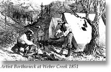 That
summer of 1848, under Captain Weber's direction,
indians labored with crude tools to wash gold from
Weber Creek. Two miles away just over the ridge
while herding cattle, vaqueros stumbled across the
rich dry diggings of present day Placerville.
Prospectors from Oregon soon join them.
That
summer of 1848, under Captain Weber's direction,
indians labored with crude tools to wash gold from
Weber Creek. Two miles away just over the ridge
while herding cattle, vaqueros stumbled across the
rich dry diggings of present day Placerville.
Prospectors from Oregon soon join them. County
roads were developed. Old Emigrant Road entered the
California Territory from Utah Territory at Genoa
in Carson Valley, Nevada. The road went south of
Silver Lake to Sly Park 14 miles east of
Placerville, and on to Diamond Springs, Shingle
Springs, Clarksville and White Rock into Sacramento
County. This is the Mormon Carson Emigrant Trail
and can be driven via Highway 88 near Genoa through
Hope Valley (Junction Highway 89) past Silver Lake
to Mormon Emigrant Trail road at Iron Mountain Ski
Resort turnoff and on to Sly Park and Sly Park Road
to Pleasant Valley Road to the town of El Dorado,
the junction with Highway 49 South.
County
roads were developed. Old Emigrant Road entered the
California Territory from Utah Territory at Genoa
in Carson Valley, Nevada. The road went south of
Silver Lake to Sly Park 14 miles east of
Placerville, and on to Diamond Springs, Shingle
Springs, Clarksville and White Rock into Sacramento
County. This is the Mormon Carson Emigrant Trail
and can be driven via Highway 88 near Genoa through
Hope Valley (Junction Highway 89) past Silver Lake
to Mormon Emigrant Trail road at Iron Mountain Ski
Resort turnoff and on to Sly Park and Sly Park Road
to Pleasant Valley Road to the town of El Dorado,
the junction with Highway 49 South.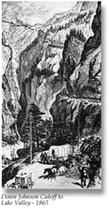 Crossing
Highway 49 in El Dorado County, Highway 50 is a special story.
John C. Johnson blazed a trail from Dry Diggings over Echo Summit
to Lake Valley at South Lake Tahoe in 1848. Johnson's Cutoff was
the most direct and quickest way over the Sierra. Stagecoaches
crossed in 1857. Improved in 1858, Hawley Grade was built by the
County down Echo Summit to Luther Pass Road. Just in time too,
because discovery of silver in Nevada's Comstock in 1859 led to
a head-to-tailgate stream east into the valley. Cargo traffic
eased after the
Crossing
Highway 49 in El Dorado County, Highway 50 is a special story.
John C. Johnson blazed a trail from Dry Diggings over Echo Summit
to Lake Valley at South Lake Tahoe in 1848. Johnson's Cutoff was
the most direct and quickest way over the Sierra. Stagecoaches
crossed in 1857. Improved in 1858, Hawley Grade was built by the
County down Echo Summit to Luther Pass Road. Just in time too,
because discovery of silver in Nevada's Comstock in 1859 led to
a head-to-tailgate stream east into the valley. Cargo traffic
eased after the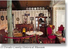 El
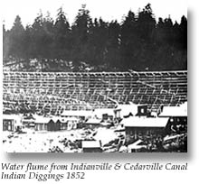
Dorado County has the finest water supply in the country. Clear
cold water from snow melt in the mountains and ample rain at lower
elevations provide year round streams and springs. Water ditches
were first used in Coloma in 1850. By 1856 other ditches and canals
followed: including Cedar and Indianville Canal, Cosumnes and
Michigan Bar Canal, Cosumnes and Prairie Canal, El Dorado and
Georgetown Ditch, Eureka Canal, Mosquito Canal, Negro Hill Ditch,
Natoma Ditch, Pilot and Rock Hill Canal, and South Fork Canal.
Also; Chilean Bar Canal, Coray & Co. Canal, Coloma Canal,
Deer Creek Canal, El Dorado Canal, Gold Hill Canal, Iowa Canal,
Union Flume, and Weber Creek and Coon Hollow Canal provided water.
El
Dorado County has the finest water supply in the country. Clear
cold water from snow melt in the mountains and ample rain at lower
elevations provide year round streams and springs. Water ditches
were first used in Coloma in 1850. By 1856 other ditches and canals
followed: including Cedar and Indianville Canal, Cosumnes and
Michigan Bar Canal, Cosumnes and Prairie Canal, El Dorado and
Georgetown Ditch, Eureka Canal, Mosquito Canal, Negro Hill Ditch,
Natoma Ditch, Pilot and Rock Hill Canal, and South Fork Canal.
Also; Chilean Bar Canal, Coray & Co. Canal, Coloma Canal,
Deer Creek Canal, El Dorado Canal, Gold Hill Canal, Iowa Canal,
Union Flume, and Weber Creek and Coon Hollow Canal provided water.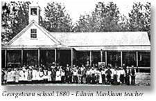 Schools.
The first schools were private and Mrs. Day was
first in 1852 and Miss Parlow's was next in 1853.
By 1857 there were 1,812 public school students in
twelve townships.
Schools.
The first schools were private and Mrs. Day was
first in 1852 and Miss Parlow's was next in 1853.
By 1857 there were 1,812 public school students in
twelve townships.Home | Hwy 49 Map | Cities Directory | Business Directory | Bed & Breakfast | Golf Courses | Wineries | Historic Churches
Gold Rush History | Historic Photo Gallery | Gold Facts | We The People | Ghosts | General Store | Old Sac | Tahoe | Yosemite
historichwy49.com
Since 1999
© 2000,
2001, 2002, 2003, & 2004 historichwy49.com
e-mail: info@historichwy49.com